- freeware
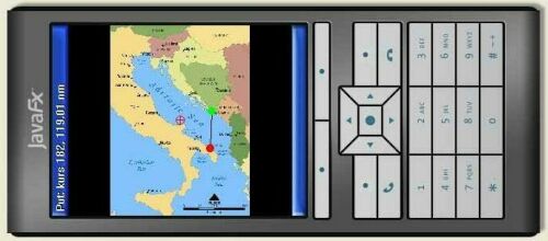
- displays map, shows position, moving direction, calculates distance and course between two point and other
- uses RASTER maps (.jpg and .png format).
- supports internal (built-in) and external (bluetooth) GPS devices
- works on any mobile phone with Java
- no any internet data transfer, works in areas without GPRS signal
Info: drshank@gmail.com
E
W
S
&
O
L
D
S
30.07.2014. For Andriod devices, there is an excellent program Custom Maps which does exactlly the same thing. So, we don't plan to port SeaSee on Android.
12.08.2013. We have been forced to change our URL from http://seasee.endofinternet.net to http://may.hopto.org/seasee. That's because DynDNS deleted hostname because of change in their "SLA policy".
30.06.2012. Version 2.2.0 released. Error handling and status line is improved.
14.02.2012. Version 2.1.0 released (on Valentine's day :D). Heading arrow is improved, speed and altitude display supported.
16.12.2011. You can also download this software at http://getjar.com/seasee
13.12.2011. Site was down again from 10.12 till 13.12 because 2nd server crashed. Both PCs dead, want boot, no beep, fans running. Installed on 3rd.
03.12.2011. Version 2.0.0 released, GPS supported
02.12.2011. Site was down from 18.11. till 02.12. because of server crash. Sorry for incovenience.
17.10.2010. version 1.0.3 released, English language built-in
13.09.2010. web site is online
06.09.2010. participated on T-Com's contest "Budi kreativan" ("Be creative")
16.08.2010. version 1.0.2 released, only Croatian language is supported
17.06.2010. version 1.0 released, only Croatian language is supported